A NOTE ON RADAR COVERAGES
and the probability of concurrent detection
an Opinion by Martin Shough
The reports of concurrent radar detection on electronically independent and physically remote instruments are the very crux of this case. However at certain times targets were observed on one or more of the several radars involved whilst there is no available report of detection on others. The question therefore arises: does the absence of available reports of concurrent detection at certain times constitute evidence material to the interpretation of any of the radar tracks? There are several issues to consider before attempting to model the several radar coverage patterns.
Firstly, the word "available" is clearly significant here. We have no explicit description of echoes on Army AAA defence-acquisition and gunlaying radars at Lakenheath, for example, although we know that TPS-1D search radar operated by the 60th AAA almost certainly did observe them. RAF Sculthorpe GCA is also known to have been alerted but no AFR 200-2 report is extant from that station, which is not positive evidence that no observations occurred there, as is illustrated by the fact that RAF Bentwaters did not transmit an AFR 200-2 report either, although we know (from second-hand reportage in BOI-485 and from the belated IR-1-56) that observations did occur there. Clearly the range-coverage of other USAF and UK civil/military radars in SE England might have offered some possibility of concurrent detection also, but equally clearly restriction on access to any documentation - if it ever existed - renders the absence of such reports not probative. It is only by chance that the Neatishead Chief Fighter Controller's account emerged at all; no official RAF report of any kind is acknowledged by the MoD to exist. It should also be remembered that IR-1-56 from Bentwaters is either edited or there was a missing report from Sculthorpe, and moreover that BOI-485 itself is only a summary, preliminary to a detailed report which was requested but never submitted (that is, not through channels yet open to public study).
Secondly the complexities of the radar environment - both topographical and meteorological - are such that models of radar coverage are of limited value. Every radiation pattern is unique, being in part determined by the siting of the antenna in relation to the local terrain, a relationship which is in continuous change as the antenna rotates through 360 degrees. Woodland, building roofs, a lake, a ploughed field, grass or tarmac - all such different scattering surfaces at different orientations and of changing wetness or dryness modify the lobe structure of the beam at different azimuths and do so differently at different times. Generally speaking, as range increases power density falls as the square, returned signal strength from point targets falls as the 4th power, cross-sectional beam area increases, and the height of the bottom edge of the beam above ground increases due to the radius of curvature of the refracted ray paths exceeding that of the earth's surface as approximately 1.33:1. The result is a complex, shifting pattern of lobes and nulls which sweeps out a rough toroidal volume of no very definite size, and the beam thus formed is still more inconstant in time due to changing meteorological conditions so that the best approximation to the ideal coverage pattern is always an heroic compromise between chance and design.
This pattern can only be defined by an operational criterion: That is, the probability of detection of a given target at a given point in space. This probability varies for different targets of different mean radar cross-section at different ranges, aspects, azimuths and altitudes; targets can disappear in the nulls between lobes, or due to shadowing of targets in the same line of sight from the antenna; targets can disappear because of blind speeds and tangential fade which might defeat simple MTI circuits of early vintage, and conversely can be masked by permanent or transient ground clutter on the PPI if MTI is not used; and there may be other introduced limitations at the display stage, such as non-linear swept gain to reduce local permanent clutter, or even physical tubemasking to prevent burning of the phosphor by such permanent clutter when electronic filters are not being used. Nowhere within the range of the set can the probability of detection be regarded as unity for a given target. Consequently the radiation pattern is defined by a set of contours representing approximate equiprobability of detection, so that good design means optimising the system for an accepted probability of detection (which might be, say, 0.8) for typical aircraft at the periphery of intended coverage, and the practical performance limitations of the radar are those experienced by the operator with a particular instrument, at a particular site, at a particular time, with a particular target in a particular atmosphere.
Thirdly, radar detection is not a purely electronic process but also involves questions of operator vigilance, the area of a controller's responsibility, current traffic and staffing levels and so forth. In other words, mere ray tracing is not sufficient to indicate whether a given aerial target should or should not have been observed, still less reported, by personnel at a given facility. With these provisos in mind an approximate model of the pattern of overlapping radar coverage zones can be attempted for the three ground radar sites from which we have available reports.
Modelling the Radar Horizons
The only parameters which it is reasonable to take account of at this stage are ranges, and radar horizons derived from a simple 4/3 earth model which is commonly used to represent the downward bending of the ray path in conditions of normal refractivity. At moderate ranges the altitude of the horizon in feet (h) is related to distance in miles (d) by the relation
h = d2/2 + 5280 d sin(n°)
where n is the effective bottom beam edge elevation.
In the absence of detailed cover diagrams for the sites in question finding n for the three cases involves some deductions and assumptions. For the CPS-5 a value for n with typical targets at moderate ranges can be found from two operational range/altitude datum points quoted as typical by the Lakenheath RATCC Supervisor. For the Neatishead GCI radars n can be estimated from guide figures and checked against one range datum for Track D, cross-correlated with an independent altitude datum derived from the CPS-5 track and bracketed by reasonable assumptions. In the case of the CPN-4 radars in use at Bentwaters and Lakenheath n can be approximated from operational data quoted in the Technical Order for minimum range/altitude performance with a T-33.
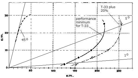
Range performance minima for a T-33 at varying elevations on the CPN-4. Cosecant2 shaping up to 45° also shown. (Adapted from tech.order data cited by Klass)
CPN-4: From the diagram above it can be seen that a T-33 is detectable at 30 miles at a maximum elevation of about 2°. Adding 20% to this minimum range performance corresponds to an elevation of 1°. It is interesting to cross-correlate these values with the result obtained for Bentwaters radar-visual Track C. Given that when d = 30 miles then h = 3600' (a value uniquely allowed by the target speed, scan rate and range asymmetry at signal loss, consistent with visual observations from ground and air, and consistent also with the ranges of the track termini for a target of cross-section comparable to a small jet), and given that sin(n°) = h/(d2/2 + 5280 d), then, ex hypothesi, the value of n at moderate ranges for the target in question = approximately 1.2°, consistent with a target having a cross-section similar to that of a small jet.
CPS-5: Given that the Track E primary target (according to the RATCC Supervisor) was stationary at the intercept point at about 16 miles range and therefore at a minimum altitude (derived from the Supervisor's experience with typical targets) of about 1500' then a horizon is indicated of approximately 1°. Similarly, given that this target was lost at a range of 50-60 miles which was "normal" for an altitude of about 5000' then we have, again, a figure of 0.9°-1.0°.
AMES Type 7, Type 13/14: Guide figures for the Type 7, and Type 14 Mk.7/9 low-cover gap filler, are tabulated below.
Range (miles) |
10 |
20 |
30 |
50 |
67 |
90 |
| ALTITUDE (feet) | ||||||
Type |
500 |
- |
1000 |
5000 |
10,000 |
20,000 |
Type 14 Mk.9 |
- |
50 |
- |
1000 |
- |
6000 |
Range/altitude guide figures for two
Neatishead ROTOR components
(see Radar Equipment - Sites and
Specifications)
The Type 7 performance at 50 miles is comparable to the CPS-5, with a horizon at about 1°, whereas the Type 14 improves the minimum elevation to about 1/5° at the same range. (These figures are believed to be for bombers over the sea and so would flatter the performances of both radars with smaller targets over land.) The Type 7 was generally the master radar, however, and inputs from the Type 14 high/low gap-filler elements would be selected by the Interception Controller depending on the needs of the interception. The Chief Fighter Controller recalled that at the time they were using the Type 7: "Type 14 is for lower, but in the main we were using the Type 7 and the Type 13 Height Finder, those were the two we were using."
As seen on the Lakenheath CPS-5 the primary target of Track E appeared to follow the departing Venom "only a short distance" SSW from the area of the interception then stopped at 10 miles S of the field. Since the Venom was departing, the GCI interception had presumably just been abandoned due to target loss at Neatishead, which therefore would have occurred "a short distance" to the NNE of this position, say between 40 and 50 miles range from Neatishead. If this sudden target loss was due (as Wimbledon early on suggested and as context arguably implies) to the target dropping below the GCI radar horizon, and if the altitude of the target at this time was similar to that indicated by subsequent signal loss on the CPS-5, about 5000' or less, then the likely approximate value of n for the elements of the GCI system in use at that time lies in the range 0.9°-1.2°. This would identify the Type 7 master radar as the surveillance element in use, which is consistent with the Chief Fighter Controller's statement to this effect.
TPS-1D: No details of observations or relevant performance guide figures are available. Context suggests that the observations reported on this radar were limited to a target or targets in the vicinity of Lakenheath, believed to be related to those echoes also detected by CPS-5 and CPN-4 radars at that airfield.
Bentwaters Tracks A, B, C & D
The above values are all fairly typical and in each case emerge with a rough internal consistency. Given the approximation involved it is probably good enough to assume an effective bottom edge elevation in each case of about 1°. On this basis each of the tracks (insofar as they can be plotted) can be considered in turn with regard to deriving some idea of the likelihood of concurrent detection.
The tracks on the Bentwaters CPN-4 are simple and linear and so can be plotted with reasonable accuracy. Ranges from Lakenheath (L) and Neatishead (N) at three points on each track - start, minimum range and end - are tabulated below. [Note: linear extrapolations of Tracks A & B beyond the points of last contact would imply reduced minimum range from Lakenheath, and these hypothetical values are also shown. In the case of Tracks C & D the ranges at last and first contact respectively are already the minimum range from Lakenheath at any point along a linear extrapolation. Similarly the ranges of all four tracks from Neatishead increase if extrapolated.]
Range (miles) |
|||||||||||
Track A |
Track B |
Track C |
Track D |
||||||||
Start range |
From L |
65 |
66 |
66 |
37 |
||||||
Start range |
From N |
57 |
50 |
50 |
51 |
||||||
Min. range |
From L |
21 |
21 |
20 |
37 |
||||||
Min. range |
From N |
41 |
44 |
44 |
28 |
||||||
Projected min. range |
From L |
2.5 |
20 |
- |
- |
||||||
End range |
From L |
21 |
21 |
20 |
74 |
||||||
End range |
From N |
42 |
53 |
56 |
29 |
||||||
Ranges of 4 Bentwaters CPN-4 tracks from Lakenheath & Neatishead
From these figures we can derive the approximate radar horizons in feet for each of the Lakenheath and Neatishead radars at the ranges of each point on each track, and a similar exercise can be done to find the approximate implied altitudes of the four Bentwaters targets from their terminal displayed ranges on the CPN-4 (the third altitude value for each track, at the point of closest approach to another radar, being interpolated from the termini on the simplest assumption of linearity). The results of this analysis are tabulated below:
Altitude (feet) |
Track/Horizon |
Start |
Minimum |
End |
Track A |
2715 |
1659 |
1659 |
L. horizon |
8385 |
2015 |
2015 |
Track A |
2715 |
1700 |
1659 |
N. horizon |
6867 |
4378 |
4516 |
Track B |
3000 |
2440 |
2440 |
L. horizon |
8590 |
2015 |
2015 |
Track B |
3000 |
2746 |
2440 |
N. horizon |
5697 |
4797 |
6182 |
Track C |
3000 |
3000 |
3000 |
L. horizon |
8590 |
1912 |
1912 |
Track C |
3000 |
3000 |
3000 |
N. horizon |
5697 |
4797 |
6692 |
Track D |
741 |
741 |
7412 |
L. horizon |
3850 |
3850 |
10354 |
Track D |
741 |
4476 |
7412 |
N. horizon |
5856 |
2771 |
2885 |
Lakenheath & Neatishead (Type
7) Radar Horizons against Bentwaters Track Altitudes at Termini
and Points of Closest Approach
[4/3 earth, n = 1°]
The degree of approximation involved in arriving at the above figures must be kept in mind. The value of n used is inferred in part from internal details and is reasonable, but is still only a guesstimate, and the values derived therefrom assume conditions of "normal" refractivity common to the ray paths from each site. It should also be noted that there is an inherent inaccuracy introduced by the 4-second "sampling" rate of the Bentwaters antenna, so that the displayed terminal ranges are not necessarily true slant ranges to a target passing out of the bottom edge of the beam. A 4000 mph target, for example, would travel >4 miles in the time it takes the CPN-4 antenna to revolve, and its trajectory could therefore intersect the angle of the beam edge at a range of, say, 34 miles although final scope contact occurred at a displayed range of, say, 30 miles. Probability suggests that the mean magnitude of any such error for the fastest tracks would be about 2 miles. This error cannot accurately be corrected, but will nowhere be very large compared to the values involved, and in the context of other uncertainties it can be neglected here.
With this caveat made, it can be shown that of the three fast tracks, A, B & C, none would have been detectable by the Type 7 radar at Neatishead at any point on their observed length or at any point on a linearly extrapolated trajectory. The slow cluster of targets on Track D would, however, probably have been above the Neatishead Type 7 radar horizon for many minutes during its progress NE from Bentwaters, and a linear extrapolation of this track N beyond Bentwaters' maximum range would imply that the targets remained in Neatishead's coverage for many minutes longer.
Conversely, Track D would never at any time have been above the radar horizons of the CPS-5 and CPN-4 at Lakenheath, but fast tracks A, B & C, whilst initially some 5000' too low to have been detected on these radars, would have entered the Lakenheath radiation patterns towards the end of their observed paths. Linear extrapolations of these three tracks would all imply some further opportunity for detection on both CPS-5 and CPN-4.
Considering first Track D in relation to Neatishead: One can be confident that this cluster of echoes, if they were from roughly isotropic radar reflectors such as aircraft or similar solid targets, should have been detectable on radars at Neatishead from, say, about 2115 to at least 2155 (remembering that the correct start time of this track appears to be about 2100, not 2130 as given in IR-1-56) and probably longer. When not far from the point of closest approach to Neatishead (order of 30 miles range) the echoes had an integrated presentation several times as strong as a B-36 on the Bentwaters CPN-4, and should presumably have been a very notable target on the much longer range (150-mile) scopes at Neatishead. Unusual targets in the easterly seaward sector, the sector of most concern from the point of view of UK air defence, would furthermore have every chance of being spotted. Yet when the Chief Fighter Controller began his shift at 2300Z, the officer whom he relieved reported "nothing unusual", which could mean either that nothing was seen or that what was seen was not considered "unusual" (that is, echoes may have been seen which resembled AP echoes and were dismissed as such). In either case this can be regarded as negative evidence. It is true that since the Bentwaters targets were heading outbound from the UK rather than approaching they may not have constituted a matter of defence interest, and it is conceivable that if no action was required then personnel at Neatishead may not have considered the incident particularly noteworthy, given that spurious AP echoes were quite common in the area. It is therefore possible that these echoes were observed but that Wimbledon's shift was not informed, in which case the strength of this evidence would depend on the unevaluable competence of the operators to determine whether they were seeing AP echoes or not.
In summary, there is no evidence that these targets were detected concurrently by Neatishead radars and this would be consistent with anomalous propagation, probably forward-scattering from turbulence associated with wind shear across an inversion layer. It might be surmised that the scattering efficiency of the responsible domains of turbulence was anisotropic due to the orientation of waves propagating under the influence of a roughly SW airflow, thus favouring energy incident at an azimuth angle near normal to the plane of the wave. Echoes might therefore more readily be observed at Bentwaters than at Neatishead, whence illumination would be more nearly parallel to the plane of the wave. At the same time time, however, there is no real positive evidence that these targets were not detected at Neatishead, and this argument is therefore inconclusive. (It should also be borne in mind that there is no positive evidence in the Hemsby vertical N-profile for a layer of refractive index discontinuity at any altitude implied by the scattering hypothesis.)
Turning now to fast tracks A, B & C, there appears to be no likelihood that targets at the implied altitudes on these trajectories would be detectable at any time by Type 7 radar at Neatishead. However the observed lengths of all three tracks do intrude into Lakenheath's CPS-5 and CPN-4 coverage zones to varying extents. These zones are of course swept volumes, and the detectable lengths and times of each track are tabulated below along with the probable maximum number of paints at 15 rpm (CPN-4) and 6.66 rpm (CPS-5).
It is assumed here that any CPS-5 scope being observed before the alert, in conditions of "very little or no traffic", would have been set to the maximum range scale. Perkins recalled that as soon as the alert came he had all the scopes set on different ranges between 10 and 200 miles. Short ranges were "necessary for making patterns at the feeder position or even surveillance finals when necessary" but, he said later, "in the pick-up position you would keep the scope on fairly long range." (It makes little difference: At 200 miles maximum range the minimum range expands to 7 miles, losing a few close-in potential paints; conversely a short range scale of say 50 miles would shrink the close-in blind spot but would lose a few paints at long range. The ranges of the unextrapolated Bentwaters tracks from Lakenheath lie between 20 and 66 miles.)
Track |
Length |
Speed |
Time |
No. of paints |
|
(miles) |
(mph) |
(sec) |
CPS-5 |
CPN-4 |
|
A |
57 |
4000 |
51.3 |
5* |
13 |
B |
42 |
4000 |
38.0 |
5 |
10 |
C |
42 |
3000 |
52.0 |
6 |
14 |
Detectability of Observed
Bentwaters Fast Tracks on CPS-5 and CPN-4 at Lakenheath
[* The number of CPS-5 paints for the extrapolated
trajectory of Track A will be reduced from 6 to a probable
maximum of 5 since it would pass as close as 2.5 miles and spend
some 12 seconds inside the minimum range.]
It is important to make a distinction between the two Lakenheath radars and the RAF air defence radars at Neatishead. The former are not operated in a continuous search function but are dedicated to the control of USAF aircraft en route and on approach, in which functions the operators are not looking for uncorrelated targets but rather are specifically interested only in certain well-identified traffic. It would be quite usual for the GCA radar to be unmanned if there were no expectation of traffic on approach, and similarly the Air Traffic Control Center would operate at a relaxed level of surveillance at times when local traffic demands were low. Even if an operator is actually looking at the scope it is not the case that every echo displayed will be attended to, let alone given close scrutiny. It can be noted that the display of the CPS-5 on the maximum range scale corresponds to an area of some 125,000 square miles.
A controller's vigilance will largely be related to the passage of traffic he expects to see, and his responsibilities at any given moment will determine factors such as the range scale selected and how much of his attention can be spared for sectors of the PPI not under his immediate control. His interpretation of the radar picture will be limited by incomplete knowledge of the complex radar environment at any given moment, and he typically has little time available to make decisions affecting the safety of the aircraft for which he is responsible, so that it is not possible "for even the most experienced operator to look at the PPI and positively identify all the echoes on scope." [Blackmer et al., 1970]
Perkins' original statement of his actions on receipt of the Bentwaters alert is probably revealing of Lakenheath ATC controllers' level of vigilance prior to this time:
I immediately had all controllers start scanning the scopes. I had each scope set on a different range - from 10 to 200 miles radius of Lakenheath. At this time I did not contact anyone by telephone as I was rather sceptical of this report . . . . There was very little or no traffic or targets on the scopes as I recall. [emphasis added]
Evidently Perkins' team was not paying great attention to the radar picture before about 2300. As he later explained:
On a swing shift late at night when you have no traffic you simply don't sit at the scopes constantly scanning them for targets. You pay little attention to targets as there were RAF aircraft, civil aircraft and others that you had nothing to do with. . . . The GCA units usually have a standby room and unless they are expecting traffic or actually handling an arrival or departure they very rarely sit in the trailer at ten or eleven at night. Ours were in the trailer at the time but that was probably because we asked them to look for the target we had been alerted to look for. [According to BOI-485 this was because, unknown to Perkins, the GCA unit had been independently alerted just after Track C at 2255Z]
It appears, therefore, that the chances of detection of the Bentwaters targets by either Lakenheath radar are quite small, a) because the GCA radar was in all probability not continuously manned, and was quite possibly not manned at all, until Bentwaters "alerted [them] to be on the lookout for unusual targets", and b) because the RATCC scopes were only being watched casually and intermittently in relaxed conditions of "little or no traffic". On the RATCC scopes the Bentwaters tracks - even assuming hypothetical extrapolations continuing into RATCC coverage at undiminished altitude, and assuming also that the CPS-5 was being operated continuously at its maximum scan rate - would in each case only present as a handful of paints, much more widely spaced than on the CPN-4 (on the order of 10 miles apart) and visible only for a matter of seconds. In the circumstances it would not be wholely surprising if such fleeting tracks escaped observation.
Lakenheath/Neatishead Track E
The intercepted target was reportedly detected in correlating locations by radars at Lakenheath and Neatishead at various times. During the interception multiple ground radar contacts at these remote locations were reportedly confirmed by AI radar on board the Venom. The subsequent loss of the target from the Neatishead scopes despite continued detection at Lakenheath has been seen to be qualitatively consistent with the lower Lakenheath radar horizon at shorter ranges.
However, the eventual northerly departure of the target as displayed on the CPS-5 from a position 10 miles S of Lakenheath to >50 miles N of Lakenheath passes within <40 miles of Neatishead (corresponding horizon altitude approximately 4000') and, if the indicated target altitude at signal loss of around 5000' represents the altitude maintained along this track, the target should therefore have been detectable at Neatishead from a position near Lakenheath out to approximately the same point at which signal loss occurred on the CPS-5 (also about 50 miles from Neatishead). This observable length of track would have a duration of some five minutes. But "although we continued to keep a careful watch [it] was not seen again" at Neatishead after the initial loss in the vicinity of Lakenheath.
The absence of reported tracking of the northbound target by Neatishead is not probative, however. Firstly, according to Perkins the target "stuck around for quite a while" as seen on the Lakenheath CPS-5 even after the second Venom had returned to Waterbeach, not departing for "30 minutes or more", which means that perhaps some 40 minutes would have elapsed since the target had been lost at Neatishead prior to the aborting of the first intercept mission. It is possible that surveillance of the Lakenheath area by Neatishead controllers was no longer "careful" by this time, attention having returned to routine monitoring of inbound targets to seaward. Indeed an aircraft-like target travelling at jet speed away from a USAF-tenanted airfield, even if noticed, would not appear anomalous, and given that Neatishead RAF personnel regarded the "UFO" incident as having been over long before there would be no reason to pay particular attention to such a target.
It is also true, of course, that the target altitude may not have been maintained at 5000' over the length of this northward track - it is presumably possible, for example, that the target climbed to about 5000' at signal loss from a lower altitude still below the horizon of the more distant Neatishead radar. At the closest approach of this track to Neatishead, range 38 miles, the Lakenheath radar horizon at 25 miles would be some 1600' lower, and the opportunity for detection at Neatishead may have been limited to a short period before signal loss, in which case a brief jet-like track detected some miles north of Lakenheath would not, even if noticed, necessarily invite connection with a target lost to the south of Lakenheath 40 minutes earlier.
Most of the plotted positions of the primary target lie within the 60-mile maximum range of the Bentwaters GCA CPN-4. A target at 5000' would have been detectable out to about 45 miles from Bentwaters and at least some of the reported target positions lie within this range, as indicated in the table below.
Range from L (miles) |
Horizon L |
Range from B (miles) |
Horizon B (feet) |
6(W) |
555 |
44 |
4797 |
20(SW) |
1912 |
45 |
4941 |
20(NW) |
1912 |
58 |
7046 |
10(S) |
930 |
34 |
3476 |
50(N) |
5697 |
78 |
11327 |
Ranges from Lakenheath and Bentwaters of Primary Target and Corresponding Radar Horizons
In each case it is true that there is a considerable altitude window of several thousand feet within which a target might be detectable at Lakenheath yet not detectable at Bentwaters. Nevertheless the above positions are clearly a small sample and presumably not representative of the the full geographical extent of the target movements during approximately 1¾ hours of tracking, so that it might be reasonable to expect that this target - particularly during passage through the SE quadrant from Lakenheath - could, at least at some time, have been above the Bentwaters radar horizon. Early ground visual observations at Lakenheath yielded altitude estimates of 2-2500', which would prejudice the chances of detectability at this time, but this value is very unreliable. Also it is evident that at least during the interception-proper, when the target was concurrently being tracked by Neatishead at moderate or high altitudes in excess of about 5000', then it should also have been easily detectable on the somewhat nearer CPN-4 radar at Bentwaters.
According to the Neatishead Chief Controller, the Type 14 (Mks. 7 & 8) radars were not being used during the interception. He recalled: "Type 7, yes. Type 14 is for lower, but in the main we were using the Type 7 and the Type 13 Height Finder, those were the two we were using." The Type 14 Mk.7 (synchronised back-to-back with the high-cover cosec2 Mk.8) was indeed a low-cover gap-filler for the 'master' Type 7 radar. The different inputs were operator-selectable. Wimbledon's recollection that the low-cover Type 14 was not being used implies that the intercepted target was not at very low altitude at this time. This reinforces the likelihood that this episode should have been detectable at Bentwaters.
A May 1957 ministerial briefing, the only extant official record of an "unexplained radar case" in 1956 which might be a reference to the August 13-14 incident, mentions
a report of an unusual object on Lakenheath Radar which at first moved at a speed of between two and four thousand knots and then remained stationary at an high altitude. No visual contact was made with this object by the Venom sent to intercept it and other radars failed to pick it up.
This is desperately unclear, but 'Lakenheath Radar' might be forgiven as a loose reference to Neatishead-and-Lakenheath radars, as Dave Clarke has suggested, bearing in mind that this briefing was prepared for an answer to a Parliamentary Question following unwelcome public excitement as a result of the recent radar sightings at West Freugh, Scotland, and the Defence Minister would be concerned to downplay the incident. In support of this one can note that no radar at Lakenheath itself had a heightfinder and thus 'Lakenheath Radar' could not alone have determined whether the object was stationary 'at an high altitude' or not. Another, probably GCI, radar is implied between the lines. In this case the "other radars" that "failed to pick it up" could conceivably include Bentwaters' CPN-4 GCA radar, and if "high altitude" means (say) 20,000' in the area of Lakenheath then an object with a radar cross-section comparable to a jet fighter should certainly have been detectable at Bentwaters.
But a statement that a radar "failed to pick up" a target must be interpreted in the light of an unknown staffing pattern at the radar site in question - in this instance, Bentwaters GCA unit. It is conceivable, for example, that the GCA trailer was no longer manned by the time Neatishead began observing the target, as this was some 45 minutes after the last 'Bentwaters' observation (2255) reported second-hand in BOI-485 (and which might conceivably not have occurred at Bentwaters at all), and 100 minutes since the last observation unambiguously recorded in Bentwaters' own UFOB report (IR-1-56). It is even conceivable that this target was intermittently observed by operators at Bentwaters, but that no report is available. (In the light of evidence that AFR 200-2 reporting regulations were not enforced in this case - i.e., the absence of required follow-up from SAC Lakenheath, the absence of an initial AFR 200-2 from Bentwaters [or Sculthorpe] and the possible exclusion from IR-1-56 of reference to Lakenheath, as suggested elsewhere - this conclusion would not be remarkable.)
Lakenheath Track F
Information on the ground-radar behaviour of Track F is not available from source and can only be inferred. The Venom aircrews describe being directed to repeated AI radar contacts with a target in the immediate vicinity of the RAF Lakenheath airfield at an altitude of about 3000'-4000' (one recollection was of about 7000'). Both Venom aircrews believed that the target remained stationary during all their attempts to intercept it. This was based on the observed rate of closure on the AI radar's PPI scope as well as on the criss-cross pattern of approaches over the same restricted area, where visible ground lights may have been a navigational reference. No information from the ground radar site (believed to have been the GCA radar) suggested to the pilots that the target was other than stationary. No information is available about the appearance or disappearance of the target on ground radar.
The times of these events (logged at between about 0200Z and 0300Z on the morning of the 14th) fall squarely within Wimbledon's shift as Chief Fighter Controller at Neatishead, yet he had no knowledge of them. However, from the limited picture above it can be inferred that a target at this altitude may have been an undetectable or marginal target on radars at Bentwaters and Neatishead. From the operational fact that normal GCI radar control was not being offered from Neatishead it is reasonable to infer that neither the Neatishead radars, nor indeed any other RAF GCI radars, had useful contact with this target.
The directing Lakenheath radar was stated to be the shorter-range GCA CPN-4. But there is no explicit information that the target was not also observed on the long-range CPS-5 of the RATCC, and indeed if it wasn't then the question arises: Why not? It seems unlikely that Perkins would not have been aware of this extended series of AI contacts by two aircraft if the RATCC radar had detected it, but it is true that this would have begun during the relief shift and probably after the time he said he had left the building (0130-0200). Just conceivably he never found out about it. But on the other hand the proximity to the airfield of the area of the interceptions might suggest that the range of the target could have been inside the minimum of Lakenheath's long-range CPS-5 and thus only detectable on the CPN-4 airfield surveillance radar. Dave Chambers, for example, pilot of Venom #1, remembered being directed overhead the airfield because the Americans "had a contact somewhere in the area of Lakenheath, either overhead or in that general vicinity", and that when they acquired the AI target it was "either stationary or in a fairly confined area . . . somewhere just over Lakenheath airfield". However the CPS-5 minimum range would vary depending on selected range-scale, and the location of the interceptions is not known with any real accuracy.
It would be very surprising if a target at a few thousand feet close to this SAC nuclear bomber airfield was not also being detected by the 60th AAA's TPS-1D search radar and/or by T-38 gunnery/Terminal Defence Area surveillance radars attached to 75mm Skysweeper AA guns. But again there is no specific evidence relating to this question.
* * *
In summary there is no completely convincing evidence that independent concurrent electronic detection of any of the targets by any of the radar sites did not occur at times when it should have done, with the possible exception of Bentwaters Track D.
In the case of the Bentwaters fast tracks the absence of reports from the three radar facilities at Lakenheath and Neatishead is intelligible in terms of radar coverages, probable levels of operator vigilance and staffing patterns. In the case of the Lakenheath primary target, Track E, the absence of information from one of the five ground radars (Bentwaters' CPN-4) is negative evidence, but it is possibly intelligible in terms of staffing patterns and/or reportorial excision and so it is not very strong negative evidence in balance with the positive evidence of concurrent detections elsewhere. Track F (stationary GCA target, air-intercepted low over the airfield during the early hours) would not be expected to be observable on radars outwith Lakenheath itself, but presumably should have been a potential target for RATCC and 60th AAA surveillance radars there. In the absence of more information the significance of this is unclear, given that simultaneous detection did indeed occur on the ground and airborne radars of which we have knowledge.
In the case of Track D, the Bentwaters slow cluster, one ought to conclude that if the echoes were solid radar-reflective targets then they should almost certainly have been observed by personnel at Neatishead. It would overstate the case to conclude that they definitely weren't observed, but there is no evidence at all that they were.